
Land Surveying
Provides High Performance Services For Multiple Industries

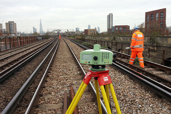
Topography Survey
A Topographic Survey is a survey that gathers data about the elevation of points on a piece of land and presents them as contour lines on a plot. The purpose of a topographic survey is to collect survey data about the natural and man-made features of the land, as well as its elevations.

Construction Staking
Construction Staking, also known as a Site Layout Survey, is the process of interpreting construction plans and marking the location of proposed new structures such as roads or buildings. Construction staking is performed to ensure a project is built according to engineering design plans.

Boundary Survey
A boundary survey is a process carried out to determine property lines and define true property corners of a parcel of land described in a deed. It also indicates the extent of any easements or encroachments and may show the limitations imposed on the property by state or local regulations.

Contour Survey
Contouring in surveying is the determination of elevation of various points on the land and fixing these points of same horizontal positions in the contour map. In the land property world, a contour is an outline of a mass of land
Alignment Survey - Road, Pipe, Railway
In a survey for a highway, railroad, or similar installation, a ground plan that shows the horizontal direction of the route. Placing of surveying points along a straight line. (mapping) Representing of the correct direction, character, and relationships of a line or feature on a map

Utility locating Survey
It is important to make accurate surveys of underground utilities so that we can find out exact locations. And also it can be known whether they need any servicing or repair, so that any kind of accidental destruction related to excavation of other projects can be prevented.

Land Partitions Survey
A partition is a division of a property held jointly by several persons, so that each person gets a share and becomes the owner of the share allotted to him. It is done by dividing the property according to the shares to which each of the parties is entitled to in law as applicable to them.

Route Survey
A route survey supplies the data necessary to determine alignment, grading, and earthwork quantities for the design and construction of various engineering projects such as roads, railroads, pipelines, and utilities
DGPS Survey
Static kinematic survey and control network survey.

CAD services
We offer a wide variety of CAD services on both an on-site and remote basis - allowing us to either work alongside other engineers or work remotely using our own hardware and software, whilst keeping the customer informed at every step of the process

Reliable, Effective & Technically Advanced Services!
Map Surv Engineering has been built on engineering excellence crafted through unstinted dedication to quality, innovation and a constant objective to serve the global market & decade young industry expertise.
Quality Control
System
Following the quality of our service thus having gained trust of our many clients. Our company develops a unique dynamically and keeps in step with the times.
100% Satisfaction Guarantee
An integrated approach to providing engineering services allows our clients to benefit from the commercial and logistical advantages.
Accurate Testing Processes
We’ll work with you on your project, large or small. Together we’ll fine-tune your new construction, remodeling or renovation plans...

Thomas Kurian
I’ve seen great companies serving industry solutions in my career. But not to the point where you feel that comfort and trust that we get with Map Surv Company.

Arun Menon
Expertly trained team members who take the extra step and go the extra mile, all to fulfill our promise, deliver innovative and dynamic solutions to our customers!

Md Saleem
I’ve seen great companies serving industry solutions in my career. But not to the point where you feel that comfort and trust that we get with Map Surv Company.

Manoj Kumar
Expertly trained team members who take the extra step and go the extra mile, all to fulfill our promise, deliver innovative and dynamic solutions to our customers!